MethaneSat: The climate spy satellite that went quiet
Satellites circling the Earth have many different functions, including navigation, communications and Earth observation. About 8%-10% of all active satellites are military or “dual use” serving intelligence or reconnaissance functions as spy satellites.
But it was a climate satellite serving as both spy and “name and shame” police officer in the sky that recently caught the world’s attention when it went quiet.
MethaneSat was developed to spot emission hot spots or plumes of invisible methane pollution from space. Built by the US non-profit, the Environmental Defense Fund with Nasa’s support, it tracked methane leaks from oil and gas sites, farms and landfills across the globe.
These are among the biggest human-caused emission sources. But methane emissions are traditionally hard to spot because they come from so many relatively small point sources or plumes.
Get your news from actual experts, straight to your inbox. Sign up to our daily newsletter to receive all The Conversation UK’s latest coverage of news and research, from politics and business to the arts and sciences.
This specialist observation satellite was developed and deployed because methane acts differently to other greenhouse gas emissions. Methane is a powerful greenhouse gas that, over 20 years, is more than 80 times more powerful a greenhouse gas than carbon dioxide.
Since 1750, additional human-caused methane emissions have contributed directly and indirectly, to around 60% of the global warming of carbon dioxide over that time.
Methane also has a short lifetime. Where carbon dioxide stays in the atmosphere for in excess of 100 years, relying on plant uptake for its removal from the atmosphere and conversion into other carbon forms, methane is broken down in the atmosphere by molecules known as hydroxyl radicals. These are nicknamed “the atmosphere’s detergent”, because they effectively remove methane from the atmosphere in less than ten years.
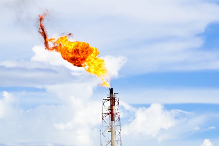
A gas flare at an oil refinery – one of many pinpoint sources of methane emissions.
hkhtt hj/Shutterstock
This combination of short lifetime and high global warming potential (a measure of the climate strength of the gas relative to carbon dioxide) makes methane both a problem and an ideal target for reduction. In fact, growth in atmospheric methane is occurring at such a rate that it is placing us dangerously off track from meeting our Paris agreement obligations to stay within 1.5°C of climate warming by 2050 and 2°C by 2100.
Eyes in the sky
But how can we achieve these reductions and what was the role of MethaneSat in seeking to meet this objective?
There are two ways atmospheric methane concentrations can be reduced. A recent and more challenging proposition is that methane is actively removed from the atmosphere.
This is difficult because it relies on technological advances that are at their earliest stages (although growing more trees can go some way to achieving this). Another more realistic approach is to reduce emissions and then to let atmospheric chemistry do the work of removing excess methane in the atmosphere.
The global methane pledge was announced in 2021 at the UN climate summit, Cop26, in Glasgow. This aimed to reduce human-caused methane emissions by 30% on 2020 levels by 2030. More than 150 countries have now signed up to this pledge. If successful, it could reduce warming by up to 0.2°C by 2050. That’s why MethaneSat was so useful.
MethaneSat is fitted with a hyperspectral sensor – which can record sunlight reflected off Earth in hundreds of narrow colour bands across the spectrum, far beyond what our eyes can see. It’s capable of picking up concentrations of methane in air at minute quantities.
This sensor allowed the satellite to spot individual plumes of methane, so it had a crucial role in identifying those problem areas. Given that these are dispersed but also individual point sources, it was invaluable in intervening in the leaks, permitting identification of those responsible so they could be held to account and so address the problem.
No one instrument can cover what MethaneSat could do with freely available data. It had high precision, high spatial resolution and, critically, global coverage and it was particularly useful at identifying plumes in nations that don’t have the resources for the sort of regional surveys using aircraft mounted systems that can fill the gap in developed regions.
Now that MethaneSat is no longer operational, there are some other tools to identify small anthropogenic emissions sources, but they tend to be regionally focused like the aircraft measurements mentioned.
Other satellites gather similar data but that data sits behind commercial paywalls, whereas MethaneSat data was freely available. Collectively, these drawbacks mean that it’s just going to be that much harder to spot the emissions MethaneSat was so good at tracking.
Don’t have time to read about climate change as much as you’d like?
Get a weekly roundup in your inbox instead. Every Wednesday, The Conversation’s environment editor writes Imagine, a short email that goes a little deeper into just one climate issue. Join the 45,000+ readers who’ve subscribed so far.
Vincent Gauci receives funding from the NERC, Spark Climate Solutions, the JABBS Foundation and has received funding from the Royal Society, Defra and the AXA Research Fund.
