I watched a simulated oil spill in the Indian Ocean – here’s how island and coastal countries worked together to avoid disaster
Preparing to react to a maritime ’emergency’. Romuald Robert, CC BY
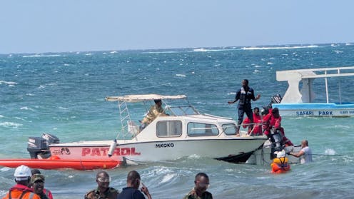
The coils of black hose, drum skimmers designed to collect oil from the ocean’s surface, and orangey-red containment booms all looked out of place on the white sand of Mombasa’s touristy Nyali beach. But on July 9, dozens of emergency responders in red and orange hi-vis gear took over a portion of this beach. They were braving the wind and choppy Indian Ocean waves as they mock up the onshore response to a simulated oil spill at sea.
I research how countries in the western Indian Ocean cooperate to make the seas around them safer, and I was there to observe a field training exercise that brought together around 200 participants from ten coastal and island states for one week in east Africa’s largest port city. Codenamed MASEPOLREX25, it put two types of emergency response to the test.
The first was Kenya’s national-level response to marine oil pollution, guided by its national contingency plan. The second was a regional-level response that can bring in outside help from other nations. The organiser of the exercise, the Indian Ocean Commission (IOC) – an intergovernmental group of Western Indian Ocean islands headquartered in Mauritius – wanted the countries of the region to rehearse a joint response to marine pollution.
Preparations begin on Kenya’s Nyali beach for the emergency exercise.
Romuald Robert., CC BY
The exercise put two IOC-designed regional centres through their paces. Think of them like a pair of regional helpdesks for ocean security, each with a distinct purpose.
How does it unfold?
The exercise began the day before with a briefing on the marine pollution scenario. The Kenyan authorities had received a distress call from the fictional captains of two damaged vessels.
An oil tanker with a deadweight tonnage of 50,000 had collided with a feeder ship in Tanzanian waters, just south of Kenya’s maritime zone. The captain of the tanker suspected that 3,000-to-4,000 metric tonnes of intermediate fuel oil (persistent, thick oil that won’t evaporate by itself) had spilled into the ocean.
Such an incident is plausible. A 2023 IOC-commissioned internal study pinpointed the Kenya-Tanzania border as a hotspot for marine pollution risk. Two major ports sit in close proximity in a busy maritime transit corridor.
Clustered around an incident board, Kenya’s incident management team mounted their national response. Nuru Mohammed, liaison officer for the Kenya Maritime Authority, explained that the assessment of the size of the spill and expectations of its behaviour had already led the team to anticipate the need for regional support. At this time of year, the sea current would carry the slick northward into Kenyan waters.
At the back of everyone’s minds was the 2020 Wakashio incident, in which a bulk carrier owned by a Japanese shipping company but flagged to Panama ran aground to the southeast of Mauritius. An estimated 800-to-1,000 tonnes of fuel oil spilled into the sea, affecting 30km of Mauritian coastline. The cost to marine life, food security and human health were compounded by economic and connectivity challenges posed by the COVID pandemic.
Responders prepare oil-spill equipment on the beach near Mombasa.
Romuald Robert, CC BY-SA
For the exercise, aerial surveillance of the mock spill triggered the first attempt at containment. A live video feed of the offshore national response showed rice husks, a substitute for the oil, afloat on the waves. Two vessels sprayed simulated oil-spill dispersants in challenging winds.
In real life, as in this exercise, oil properties determine how the spill will behave. IOC consultant Peter Taylor warned that churning waves could mix with the oil forming emulsions that were viscous and not dispersible.
We turned our attention to the chat feed on SeaVision, an information-sharing platform. A notification popped up. The Regional Maritime Information Fusion Centre (RMIFC) in Madagascar had shared mapped and timestamped projections of the drift of the oil slick for the following 72 hours. The centre’s director, Alex Ralaiarivony, later explained how it could provide other technical support such as satellite imagery, and could calculate the proportions of oil that were likely to become submerged, evaporate, remain adrift and reach the shoreline.
By July 9, the fictional oil spill had reached the coast. The team on Nyali beach hurried to deploy an oil containment boom, a floating barrier that can shield sensitive areas such as shorelines.
Back at headquarters, SeaVision was busy with messages. The other centre, the Regional Coordination of Operations Centre (RCOC) in Seychelles, was urgently requesting more shoreline equipment to help with oil spills, such as booms, from regional partners. Mauritius and Madagascar both made offers to help that Kenya accepted, and the RCOC coordinated a Dornier aircraft from Seychelles for collection and delivery.
How does the emergency response work?
The two centres help countries in the Western Indian Ocean secure their maritime zones against threats such as piracy, illegal, unreported and unregulated fishing, the trafficking of illicit goods – and marine pollution incidents.
In Madagascar, the RMIFC gathers and analyses maritime data from multiple sources to detect potential threats at sea. This enables early warning of threats like oil spills, as well as suspicious ships or boats engaged in illicit maritime activities.
The RCOC in Seychelles responds to these threats. It draws on a shared pool of aircraft and ships belonging to its members, using these to coordinate joint responses – whether through sea patrols, boarding and inspecting ships, or laying the legal groundwork to prosecute offenders.
The two regional centres serve seven states: IOC island members Comoros, Madagascar, Mauritius, Seychelles and France — through its island territory of La Réunion — as well as East African coastal states Kenya and Djibouti.
On July 10, the exercise ended with an evaluation. One takeaway was that the two regional centres could have been used even more – for instance, to coordinate technical assistance from different partners. But a key purpose of the exercise was to help participating countries understand what the centres offer, and get them used to a regional-level response.
Coastal and island states thousands of kilometres apart are being brought closer by maritime threats in their shared ocean. And the two centres are building their operational capacity to support the whole region, while also creating trust among countries. This matters in a geopolitical context of strategic competition in the Indian Ocean, where islands and East African coastal states sometimes want to put their own needs first.
At the end of the exercise, IOC officer-in-charge Raj Mohabeer reminded participants that the island and coastal states of the Western Indian Ocean have vast maritime zones and face multiple seaborne security threats to their economies, ecologies and livelihoods. “No developing country can deal with a significant marine pollution event alone.”
Kate Sullivan de Estrada receives funding from Research England’s Policy Support Fund allocation to the University of
Oxford via the Public Policy Challenge Fund. Her project under the Fund is titled “Balancing ‘Sovereignty Trade-offs’ in Small-State Maritime Security Co-operation: The Case of the Indian Ocean Commission.”

